


We have updated the Consolidated Layer of Ecosystems
The first version of the Consolidated Layer of Ecosystems was compiled by the Nature Conservation Agency of the Czech Republic in cooperation with CzechGlobe and the Global Change Research Centre of the CAS in February 2013 as a basis for the mapping of ecosystem services, which was part of the project Integrated Assessment of Ecosystem Services in the Czech Republic funded by the Technology Agency of the Czech Republic. In September 2021. Now, the Consolidated Layer of Ecosystems was updated thanks to the One Nature project.
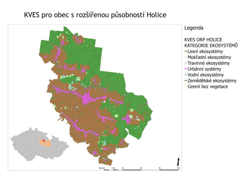
The Consolidated Layer of Ecosystems is a detailed and seamless layer of landscape cover which includes the entire territory of the Czech Republic. The most detailed and up-to-date data available were used as input. The Layer divides the landscape cover into 42 different categories such as water network, transport network, cultivated meadows, alluvial meadows, continuous urban and built-up area, arable land, and others. These 42 categories fall into seven broad groups: urban systems, agricultural ecosystems, grassland ecosystems, forest ecosystems, wetland ecosystems, aquatic ecosystems, or areas without vegetation. The basic mapping unit of 25 ha is close to the detail that is discernible by humans in field mapping.
The resulting Consolidated Layer of Ecosystems is a compilation of six very detailed data sources. The following data sources have been used to update the Consolidated Layer of Ecosystems: the basic geographic data base of the Czech Republic – ZABAGED, the public land register (LPIS), data from the Forest Management Institute, the European Environmental Agency’s (EEA) Corine Land Cover data, the EEA’s Urban Atlas dataset of landscape cover in urban areas, and the Biotope Mapping Layer of the Nature Conservation Agency of the Czech Republic.
In addition to updating the old data, the new version of the Consolidated Layer of Ecosystems has been enriched by the dataset of commercial forests and scattered vegetation from the Forest Management Institute. The procedures for creating the categories of watercourses, transport network and arable land have also changed. The updated version should be more accurate, the data should be linked to each other topologically.
The updated habitat mapping layer (version 2020) was the main input. In the natural habitat segments, the habitat mapping layer was given priority. As each part of the territory of the Czech Republic had to be identified with one of the 42 defined categories, those who worked on the updated Consolidated Layer of Ecosystems had to deal with mosaics, i.e. segments containing several types of habitats. In the case of mosaics up to one hectare in area, they assigned the segments to the predominant habitat. If the ratio of represented habitats was 1:1, they considered the entire mosaic to be the habitat that was in more favourable condition according to the quality assessment.
The next generation of the Consolidated Layer of Ecosystems is likely to be based on satellite data instead of vector data from local databases. The vision for the future Consolidated Layer of Ecosystems is to head towards automatic updating, which may increase the frequency of data updates. Our aim is to achieve higher accuracy, reliability and compatibility of the source data.
Thanks to the update of the Consolidated Layer of Ecosystems, which is an integral part of the One Nature project actions, it will be possible to better assess the socio-economic benefits of the Natura 2000 network. In practice, this is an indispensable source material for the assessment of ecosystem services that various entities use for research or landscape studies.

The detail of the Consolidated Layer of Ecosystems for the municipality of Holice
Information with metadata about the Consolidated Layer of Ecosystems can be found at metadata.nature.cz.
The Consolidated Layer of Ecosystems is provided at the Mapomat (Natural Conditions section; only in Czech).

